According to Bill Diven’s Sandoval Signpost article, “Heil’s amendment on November 16th, which passed 4-1, would make such development a conditional use in areas already designated in the Comprehensive Zoning Ordinance as community districts and overlay zones. Those 11 areas already have extra and varying zoning protections and include most of Placitas plus Algodones, Rio Rancho Estates, La Cueva, and the Jemez Valley corridor including San Ysidro.”
But NOT all Community Districts Overlays will have the same zoning. For example, Rio Rancho Estates has a permissive use zone in the overlays districts, so there would be no changes to protections of the Municipal Drinking water wells that over 100,000 people rely upon. While many Environmental groups advocate for Equal protection the only overlay districts we can find that will get a public notice and a public hearing is Placitas, at the Dec 6th, East Mountains community meeting, Commissioner Holden-Rhodes mentioned “Exclusion Zones” meaning the community district overlays as a way to Exclude certain activities. As it now stands this is unequal protection. These can be found in the Comprehensive Zoning Ordinance.
Under conditional use, a drilling applicant would need to meet the same requirements for a permit, but instead of the zoning director making the decision, approval would be up to the Planning and Zoning Commission after a public hearing. Permissive use does NOT require that process, and the County no longer has a special-use zoning permit in the Comprehensive Zoning Plan. It is only under a Special-Use permit that the County has the authority to reject a permit. As long as certain conditions are met – in an administrative procedure, they cannot disallow the permit application. Bernalillo County has this copy to help the general public understanding permitting.
On December 14th, 2017, commissioners – during their one meeting for the month, are expected to vote on publishing the ordinance. That triggers a 15-day public notice period… making the January 4th, 2018, meeting the earliest commissioners could take action on the ordinance itself.
As of Sept 21th, 2017, the County adopts the Oil and Gas 9-page ordinance.
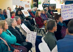
County Pulls a Bait and Switch on Citizens’ Input Process on Ordinance This ordinance lacks adequate protections for water, air, and public safety. Many issues are not addressed.
Commissioner James Holden-Rhodes of Placitas attempted to table the ordinance until New Mexico Tech can finish its assessment of oil and gas resources relative to potential sources of groundwater in the county. His motion drew raucous applause but only one other vote, that from Commissioner Kenneth Eichwald of Cuba, the sole Democrat on the five-member body.
The $62,000 project began in July with the final report not expected until May of 2018. The county has contracted NM Tech as a consultant on developing the zoning ordinance that would apply only to surface issues on private lands outside municipalities.
Our Position Statement on the NM Tech Study
There are two parts to it: 1) primary goal to locate oil and gas resources that can be explored in the county; and 2) assessment of impacts to nearby aquifers. So they are looking at aquifers in a limited way, not like a hydrological assessment would but just in terms of limitations on oil and gas exploration posed by aquifers and geology in general if that makes sense. It would help to identify areas where oil and gas exploration would pass through aquifers or nearby and the relative depths of aquifers and oil/gas wells in relation to one another is an important factor in whether damage could be caused to water resources and how high that risk is. Interestingly though there is no mention of surface water supplies which the EPA also mentioned are at just as high, if not a higher risk of contamination from fracking specifically, which tells us that the goal was not to protect water resources but just to account for whether they would impede oil and gas exploration.
In the link above the NM TECH Study and the Staff report on Sandridge permit application under special use. When one reads the staff report we see a 180-degree position change when Commissioner Chapman became chair.
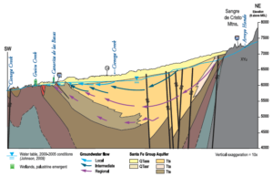
Geology underlying the county was one recurring theme during the meeting. Speakers focused on the difference between the northwest, which includes part of the San Juan Basin with its history of oil and gas production, and the southeast, which includes part of metro Albuquerque where 800,000 residents rely in large part on groundwater.
While the geology of the northwest is relatively simple, the southeast also includes the Rio Grande Rift, one of the few rift valleys in the world visible on land. Here the earth’s surface is slowly pulling apart fracturing subsurface layers from Colorado into Mexico.
“Not taking into account the geology is a big problem,” said professional geologist William Brown of Placitas. The faulting along the rift increases the potential for drilling into a petroleum-bearing layer on one side of a fault line affecting a water-bearing layer directly opposite on the other side, he said.
“Placitas is the area that probably has the greatest potential for contamination,” Brown told commissioners. “There’s a huge number of faults in the Placitas area. It’s so complex that you can’t go up there and do horizontal fracking.”
Brown recommended dividing the county into zones with more stringent permit requirements including public hearings for sensitive areas.
Another geo-hydrologist working with the Placitas Citizens Group is making rounds to talk with the commissioners. Recently, Commissioner Holden-Rhodes distributed a letter regarding the hydrology and faults within the basin and the implications of earthquakes and strata vulnerability. The most recent earthquake was located in Cochiti Pueblo area. An Earthquake in the area of Cochiti Dam, which is an earthen dam, would be vulnerable to a catastrophic event causing death and destruction of the several pueblos and traditional towns and villages along the Rio Grande. Holden Rhodes sent a letter to the Community regarding his take on the water issues It is abundantly clear from the reports released to the public that drilling in the Rio Grande Basin would impact fault zones and may cause the destruction of perched sub-basin aquifers which Rio Rancho gets its water. In the Ortiz Mountains, East mountains, because of the uplift in geological strata it is equally important not to destroy private property values by destroying the groundwater supply.